• Hallo Gast, wir suchen den Renner der Woche 🚴 - vielleicht hast du ein passendes Rennrad in deiner Garage? Alle Infos

Aktuelles Kartenmaterial für Wahoo ELEMNT BOLT, ROAM, ELEMNT selbst generieren

Das Fadenkreuz kommt bei: ROUTE -> TAKE ME TO -> LOCATION ON MAP
Kannst dort die Karte li/re/ho/ru schieben und zoomen.

Eine Frage zum VTM-ForcedRoam1 Theme
- Dort sind oft Farben definiert, die der RoamV1 nicht darstellen kann. Das verwundert mich. Was macht der V1 dann mit der Farbe?

Und eine Frage zur Germany-Elevation-Karte:
- Basiert diese auf den orig. OSM-Karten? Ich frage deswegen, weil mein bisheriges VTM-XML-Theme diverse Straßen und Radwege dort jetzt anders darstellt als mit den orig. Wahoo-Karten. Sprich diese Straßen haben dann in den beiden Karten unterschiedliche Identifier / Tags (ich hoffe ihr wisst was ich meine)?
 

Anzeige

Re: Aktuelles Kartenmaterial für Wahoo ELEMNT BOLT, ROAM, ELEMNT selbst generieren
Bitte zu beidem Beispiele am besten in code.
diese Farben kann der RoamV1 darstellen:
XML:
<!-- #000000 Color Hex Black   -->
<!-- #FF00FF Color Hex Magenta -->
<!-- #0000FF Color Hex Blue1   -->
<!-- #00FFFF Color Hex Aqua    -->
<!-- #00FF00 Color Hex Green1  -->
<!-- #FF0000 Color Hex Red1    -->
<!-- #FFFF00 Color Hex Yellow1 -->
<!-- #FFFFFF Color Hex White   -->

und im VTM-ForcedRoam1 Theme bspw. diese hinterlegt:
XML:
<m e="way" k="highway" v="primary_link|trunk_link|motorway_link|primary|trunk" zoom-min="9">
  <line cat="roam" outline="roam-major-roads" stroke="#FFAA00" width="3.5"/>
</m>
<m e="way" k="highway" v="motorway" zoom-min="12">
  <line cat="roam" outline="roam-highway" stroke="#BB0000" width="4"/>
</m>
<m e="way" k="highway" v="motorway" zoom-min="8" zoom-max="11">
  <line cat="roam" outline="highway-roam" stroke="#BB0000" width="4"/>
</m>

Für meine Vermutung mit den unterschiedlichen OSM-Tags in den beiden Karten habe ich keinen Code. Aber je nach dem, welche Karte mit meiner selbst angepassten XML angesprochen wird, werden gewisse Strassen anders dargestellt. Sprich der Radweg am See ist einmal gepunktet (meine XML i.V.m. der Germany-Elevation-Karte), einmal in Magenta (meine XML i.V.m. der orig. Wahoo-Karte).
 
Der Mehrwert der Höhenlinien erschließt sich mir nicht so recht, die sind so blass und kontrastarm, dass man sie bei der Fahrt eh nicht erkennen kann, ein Blick auf die barometrische Altimeterangabe ist doch eh viel präziser. :D
 
Für meine Vermutung mit den unterschiedlichen OSM-Tags in den beiden Karten habe ich keinen Code. Aber je nach dem, welche Karte mit meiner selbst angepassten XML angesprochen wird, werden gewisse Strassen anders dargestellt. Sprich der Radweg am See ist einmal gepunktet (meine XML i.V.m. der Germany-Elevation-Karte), einmal in Magenta (meine XML i.V.m. der orig. Wahoo-Karte).
Das hier meine ich, links die Germany-Elevation-Karte, rechts die orig. Wahoo-Karte:
IMG_9798.jpg IMG_9799.jpg
Es geht um den Radweg am See, der im rechten Bild (der Pfeil) so dargestellt wird wie in der XML.
Die XML ist in beiden Fällen die gleiche, habe den ganzen vtm-elemnt Ordner auch hier im Post angehängt. Die vtm-elemnt.xml ist wieder ein bisschen verbessert: Bebauung mit dem light_red.png, Bundesstrassen rot, Autobahnen fett in blau, alles geforced auf den RoamV1 (analog dem entspr. geforceden HiDrive-Theme) und optimiert fürs Rennradfahren (es sind nur asphaltierte Straßen und Wege farbig, alles unbefestigte ist gepunktet oder ähnlich schwach dargestellt, das zugrunde gelegte orig. Theme war das von Zenziewerken). Wald funktioniert ja seit geraumer Zeit. Im Bild rechts sieht man auch etwas gelben Strand, der offensichtlich in der Germany-Elevation-Karte fehlt.
 

Anhänge

  • vtm-elemnt.zip
    336,5 KB · Aufrufe: 41
Zuletzt bearbeitet:
Der Mehrwert der Höhenlinien erschließt sich mir nicht so recht, die sind so blass und kontrastarm, dass man sie bei der Fahrt eh nicht erkennen kann, ein Blick auf die barometrische Altimeterangabe ist doch eh viel präziser. :D
It was a request on Treee111's github page. How good or bad you see them is naturally depended on how dark/thick you define them in the theme. Don't like or need them? Just remove the section from the theme. :)

diese Farben kann der RoamV1 darstellen:

You are absolutely right. But up until a couple weeks ago I was just creating the map maker and the maps themselves. It's just these last weeks I took a look at the theme's when I heard some things were not working. The theme's as they are, are mostly old in the sense they are parts of originally Wahoo theme's (when they still did support the bolt and roam 1 in the vtm theme) and the work of Zenziwerken (who dropped bolt 1 support a little while back and stated he did not know how it would work/look on the roam(1))
Until shortly if you used the bold2 theme (basically the only one there was) on your roam1 you where worse of then now. Let alone what you saw on a bolt 1.
I think it has also been said here, but I myself have just a bolt 1 so for improvements/color suggestions etc I am depended on the people who have those devices like you and report back.
So thanks for this!

Für meine Vermutung mit den unterschiedlichen OSM-Tags in den beiden Karten habe ich keinen Code. Aber je nach dem, welche Karte mit meiner selbst angepassten XML angesprochen wird, werden gewisse Strassen anders dargestellt. Sprich der Radweg am See ist einmal gepunktet (meine XML i.V.m. der Germany-Elevation-Karte), einmal in Magenta (meine XML i.V.m. der orig. Wahoo-Karte)
Hard to say without (or even with) an example. But the newest original Wahoo maps are from January 2022 I believe. Roads can have been reclassified.
This is the path now on osm https://www.openstreetmap.org/way/167875087 but it has indeed been changed a year ago https://www.openstreetmap.org/changeset/111260910?way_page=2 (scroll down to the ways) If I read it correctly, it had highway=path added. So indeed it could be rendered differently now.
 
Zuletzt bearbeitet:
Looking into this has made me see other "strange" things. As said I am not the creator of the base theme's but looking at the trails section I suddenly realize there are non osm tags in there like bic_designated.
The osm tags are bicycle=designed not bic_designated. So a theme rule would/should not be activated.
The only reference I find when doing a quick google is in the tagmapping for openandromaps.
Going to see if I can find something out tomorrow!
Turns out the answer is in the notes.md file in the theme cl posted. I will have to change somethings in the theme files. Hopefully I will post them tomorrow.
 
Totally awesome work @Ebe66 . I actually just need to know if the HiDrive map (germany-elevation) is 100% OSM based. Now I think to 101% yes ;-). So I can try to re-address the tags in "my" edited XML-Layout and maybe fix some other issues you described above.
 
Oh yes, it's 110% osm ;-)
Hope it makes sense, but there is no bic_dedicated in my maps for example. It seems that Zenziwerken put that in his tag-wahoo.xml as sort of shortcut to the tags designated and official.
Now the solution is to:
  • Re-generate the whole map with his settings.
  • "expand" the tags in the theme. (bic_designated becomes designated|official etc
I prefer the second option, because the theme than follows the official osm guides again.

Oh and color suggestions are welcome. Don't say I will always use them, some colors are already tested and "on request" in some themes.
What I suspect the roam 1 does with colors it can't display is just use the parts it can. So #FFAA00 (don't know how it got in there) would be displayed as pure red, again I think. The FF being displayed and the AA not being displayed.
The device itself does not seem to care. The only way I found out that the device detection is not working anymore was by taking a screenshot (with the elemntary app) of my b/w bolt 1 and getting a color image!
After that it was easy to work out it was actually using the bolt 2 theme and colors...
 
Oh yes, it's 110% osm ;-)
Hope it makes sense, but there is no bic_dedicated in my maps for example. It seems that Zenziwerken put that in his tag-wahoo.xml as sort of shortcut to the tags designated and official.
Now the solution is to:
  • Re-generate the whole map with his settings.
  • "expand" the tags in the theme. (bic_designated becomes designated|official etc
I prefer the second option, because the theme than follows the official osm guides again.
yes, definitely the second option, also with regard to upcoming OSM maps

Oh and color suggestions are welcome. Don't say I will always use them, some colors are already tested and "on request" in some themes.
What I suspect the roam 1 does with colors it can't display is just use the parts it can. So #FFAA00 (don't know how it got in there) would be displayed as pure red, again I think. The FF being displayed and the AA not being displayed.
The device itself does not seem to care. The only way I found out that the device detection is not working anymore was by taking a screenshot (with the elemntary app) of my b/w bolt 1 and getting a color image!
After that it was easy to work out it was actually using the bolt 2 theme and colors...
In such cases, I often do some trial and error work. :D
 
Trial & Error #1 - Zoom Level:
https://github.com/treee111/wahooMa...GS_ON_MAP_AND_DEVICE.md#zoom-levels-and-scaleZoom-Levels für den RoamV1 sind die Folgenden:
XML:
        <!-- zoom-min="10" => ab     Zoomlevel   10 km  & (+) sichtbar -->
        <!-- zoom-min="11" => ab     Zoomlevel    5 km  & (+) sichtbar -->
        <!-- zoom-min="12" => ab     Zoomlevel    2 km  & (+) sichtbar -->
        <!-- zoom-min="13" => ab     Zoomlevel    1 km  & (+) sichtbar -->
        <!-- zoom-min="14" => ab     Zoomlevel  500 m   & (+) sichtbar -->
        <!-- zoom-min="15" => ab     Zoomlevel  200 m   & (+) sichtbar -->
        <!-- zoom-min="16" => ab     Zoomlevel  100 m   & (+) sichtbar -->
        <!-- zoom-min="17" => ab     Zoomlevel   50 m   & (+) sichtbar -->
        <!-- zoom-min="18" => nur im Zoomlevel   20 m         sichtbar -->
 
@*cl* Just to let you know, the missing beach seems indeed to be a omission in the Germany elevation map on the hidrive. I re-rendered Sachen and this is the result now (I have been trying a lot of things recently)

Screenshot 2023-02-25 150009.png


Why the path renders as a footpath is atm beyond me...
I'll upload Sachen to the hidrive in a minute so you can test yourself.
 
@*cl* just uploaded another new version of Sachen. Could you please give it a try?
I really need to look into the render theme xml it seems. When I (re)included Zenziwerkens <osm-tag key="bicycle" value="bic_designated" equivalent-values="designated,official" renderable="false"/> etc. in the tag-wahoo.xml and used them in the theme it all came together it seems. Don't understand why but for me it now looks like this with my roam 1 vtm theme:
Screenshot 2023-02-25 180431.png


Your's, I'me afraid, still looks pretty much the same over here.
 
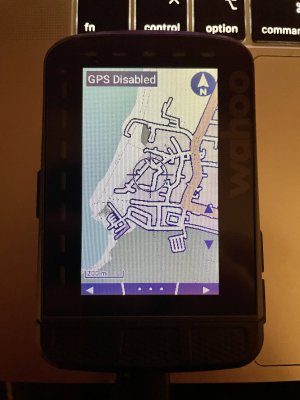
@Ebe66 here is the result at the RoamV1 with my XML (some landuse building currently in a dark_red.png pattern under testing, bicycle way not yet updated, coming soon along with some zoom-level-editing):
IMG_9805.jpg
Beach is visible now :)
 
Last time for today (hopefully). The "problem" in your theme seems to be the use of roam-trail in this block:
<m e="way" k="highway" v="path" zoom-min="12" select="first">
<m k="bicycle" v="bic_yes|bic_designated">
<!-- specifically for cycle -->
<m k="surface" v="bic_paved">
<line use="roam-trail" outline="roam-bikepath"/>
</m>
Which is a very thin line, width="0.1", for a bicycle designated, paved path? Difference in display with the old wahoo maps probably being the addition of highway=path to the way.
My XML-Theme I was editing by trial&error for the original Wahoo maps until it looked fine for me. No problem at all, I just do some more editing based on your HiDrive maps until it looks fine for me again. Great thanks for your work.
 
Hallo zusammen,
ich hatte nochmal das Thema adb device Zugang mit meinem Roam V1 probiert. Dabei auch i ausgeschalteten Zustand alle 3 Tasten (+ / - und Power) gleichzeitig gedrückt. Nun lässt sich der Roam nicht mehr einschalten.
Das heißt, das Display bleibt dunkel. Auch beim Anstecken des Ladegerätes zeigt das Display nichts an.
Gibt es da noch irgend einen Trick, das Ding zu reaktivieren?

Vielen Dank.
 
Zurück
Oben Unten